Competition date: June 21 and 22, 2025
Competition venue / Location of the competition: Tome Parish, Ogre Municipality
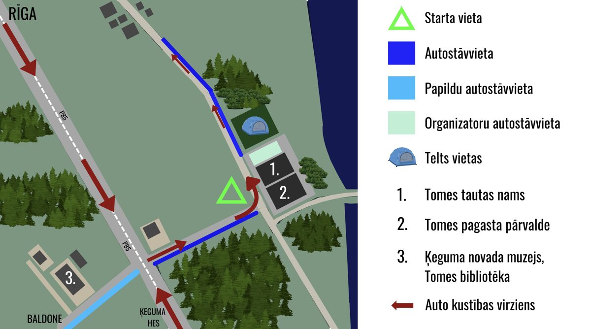
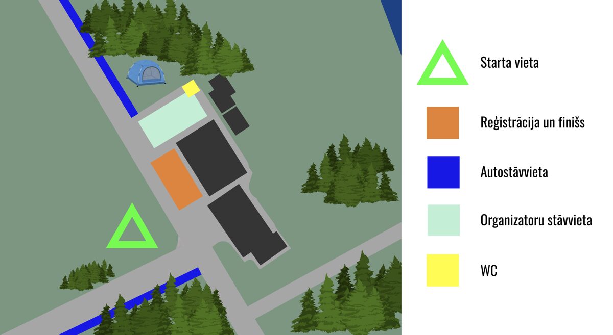
Sacensību centrs: Tomes Tautas nams ("Ābelītes", Tome, Tomes pagasts
Ogres novads, LV-5020). It will have toilets, areas for course planning (both outdoors and indoors), waste bins, tent spaces for sleeping, and other amenities.
At the finish – beer, kvass, cheese and soup, and sweet pretzel cake.
Waze: https://ul.waze.com/ul?ll=56.75438582%2C24.64423084&navigate=yes&zoom=17&utm_campaign=default&utm_source=waze_website&utm_medium=lm_share_location
Google Maps: https://maps.app.goo.gl/seqZ5vt9yxBsrKxq9
ORGANIZED BY: Association
K-PUNKTS in cooperation with the Latvian Orienteering Federation and the Tome Parish Administration
SUPPORTERS: SIA “MASTAKS”, Ezītis miglā, Pašdarinātas brošas, DELFI, Saldsstūris,
Lapsu Mājas siers, Sierštelle, Masterprint, Intervals.lv
Competition Director: Elīna Krēmere
Competition map, DISTANCE: Krišjānis Krēmers
The competition is included in the LOF competition calendar.
ATTENTION!!!
- In the competition area, 50 control points will be placed – orienteering prisms with reflectors and punching stations. The maximum obtainable points by visiting all control points is 239 points.
- The time for receiving the rogaining maps is scheduled 15 minutes earlier than originally stated in the rules (at 17:45) to prevent crowding in the start corridor, which will be opened at 18:45 (please arrive at the start on time!). Each participant will receive one map plus one additional map for team route planning.
- Please strictly follow the car movement scheme indicated below – this is necessary so that we can efficiently organize vehicle movement both when arriving and leaving the Saulgrieži rogaining event.
- As you approach the competition center, you will see guys in orange vests. They will clearly explain where and how it is preferable to park your car. Please reduce your speed, especially near the competition registration and start areas.
- As you can see, the competition center is located very close to the P85 highway. Let’s be careful when moving around not only during the rogaining event but also before and after it!
- During the competition, we ask you to protect and respect both people and nature. It is strictly forbidden to throw trash in the forest or anywhere else where it is not designated!
When completing the rogaining distance, it is forbidden to cross:
- Cultivated fields
- Microlimits, especially dangerous and prohibited areas marked on the map with a purple grid
- Cemeteries, house yards and gardens (marked in olive green), unless a road goes through them. It is recommended to go around houses to avoid disturbing residents.
Remember, it’s night!
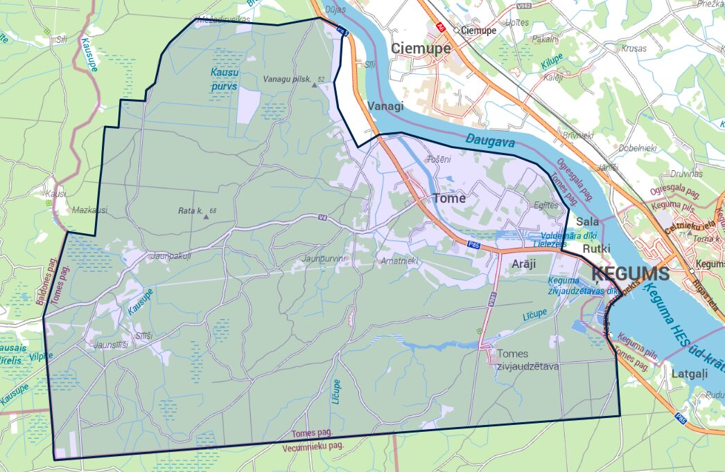
Saulgrieži rogaining area
Competition center schemes
Competition Program
from 16:00 participant arrival for 3 and 9 hour competitions at the competition center, registration
17:15 orienteering training, answering questions
17:45 map distribution for 3 and 9 hour competitions
18:45 start corridor opening
19:00 start of 3 and 9 hour competitions
22:00 finish of 3 hour competition
22:22 sunset
22:30 end and awarding of 3 hour competition
4:00 finish of 9 hour competition
4:29 sunrise
4:30 end and awarding of 9 hour competition
6:00 competition center closing
What to keep in mind when arriving at the competition center?
- When registering, team members confirm with their signature that they take responsibility for their own safety and health, have familiarized themselves with the rogaining competition rules (https://rogaining.lv/jaunumi/data/augsuplades/files/DOKUMENTI/IRF%20Rules%20of%20Rogaining%20-%20Current%20as%20of%20the%201st%20January%202024.pdf),
competition regulations (https://www.k-punkts.lv/rogainingi/saulgriezu-rogainings/nolikums/)
and commit to following them. Participants agree not to make claims against the organizers for injuries caused by overestimating their abilities, not assessing conditions, carelessness, or lack of experience.
- If a participant is under 16 years old, verbal or written parental/guardian permission is required to participate. Written permission is necessary if the parent/guardian is not present at registration and must be written in free form.
- By registering and participating, participants agree that photos and videos taken during the competition may be used for publicity of this and other competitions, promotion of an active lifestyle, and the use of personal data provided in the application for team composition publication, result compilation, and publication in print, electronic media, and social networks.
Comments from the map and distance supervisor, who has already spent quite a long time in the terrain
- The forest has many insects (mosquitoes, horseflies, etc.), dress accordingly and use insect repellents
- The map size will be 48.4 x 69.9 cm, paper with double-sided matte laminate, moisture resistant in rainy conditions
- Scale 1:20,000, contour lines every 3 m. The rogaining map prepared in 2025 uses topographic materials from the Latvian Geospatial Information Agency (LĢIA), orthophotos (2020), Latvian State Forests (LVM GEO) data, terrain reconnaissance, and other information
- The terrain is mostly relatively runnable and easy because mostly pine forests. Around the start, there will be several deep, overgrown ditches filled with water, while on the western part of the map ditches are mostly dry/semi-dry and easy to cross. Crossing Līčupe and Kausupe rivers might be difficult, as water is mostly knee-deep. Most swamps are dry; however, considering recent weather, swamps and ditches could be full of water. The map shows a wide network of paths and roads, mostly very visible paths, though some may be overgrown. Active forest logging and cleaning is ongoing in the area, so new clearings or unmarked roads may be found. The middle part of the map is hillier, offering beautiful nature views. There are quite a few animals in the forest; you might encounter a fox, roe deer, owl, or crane.
Worth remembering
- Participants are allowed to use only a compass, watch, and the competition map issued by the organizers for navigation during the competition, and movement is allowed only on foot without using aids
- Although most private landowners in the area have been informed about the competition, please do not cross private yards, do not climb over fences, be cautious of dogs, etc. Be careful near electric fences as well.
- Three water points with reservoirs will be placed in the competition area, one will be an LVM rest spot with a campfire, snacks, and a special atmosphere.
- For every minute delayed, 1 point is deducted from the team. For example, if the team is 5 seconds late (-1 point), 1 minute and 20 seconds (-2 points), 3 minutes and 59 seconds (-4 points). If the team is 30 minutes or more late, the result is disqualified.
- If any team member is found with a damaged (broken) SI card wrist attachment at the finish, the team may be disqualified.
- Ignoring instructions, rules, or additional directions from organizers may lead to participant/team disqualification. Participation under the influence of alcohol or narcotics, reckless behavior, and disrespect towards other participants and organizers is also prohibited.
Applications
A limited number of teams will be able to register on the competition day on-site (after notifying via email [email protected]), filling out the application by hand.
Awards
The top 3 scoring teams in each time and participant category will be awarded.
Contact information: Elīna Krēmere
(+371) 22022054, [email protected]